However in this case the map-maker was no average artist; he was the great renaissance man Leonardo da Vinci (1452 - 1519).
In 1502, between his creation of his Vitruvian Man and his painting of The Mona Lisa, da Vinci was hired by the notorious politician Cesare Borgia, whose forces had captured the city of Imola three years earlier as he sought to expand his power base in Northern Italy.
As an ambitious military tactician, Borgia realised he needed an accurate map of his new city but could do without the traditional dragon in the corner so looked for a skilled cartographer to complete the task and soon began a quest to persuade da Vinci to leave his comfortable studio in Rome for an expedition to the north.
As da Vinci had recently developed the hodometer and magnetic compass, he was able to use these surveying tools to plot accurately the position of objects on the ground and translate these onto paper, ensuring his depiction of Imola was more than just a romanticised view of the city traditional at the time but instead was one of the first workable maps from that period of history.
Borgia, the illegitimate son of Pope Alexander VI and an inspiration for Machiavelli's 'The Prince', was feared as one of Europe's violent rulers but realised he had little knowledge of the layout of the new city to be added to his principality.
Therefore in 1502 he turned to da Vinci, whom he respected as an engineer, a pioneering scientist and a skilled surveyor as much as a renowned artist, and the military ruler commissioned this important map of the city his forces had captured three years earlier in 1499.
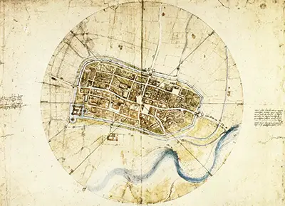
Instead of providing a traditional drawing of Imola's palaces and churches, da Vinci showed the city from above and marked the points of the compass around its circular wall, in a precursor to the compass symbol seen from that point forward on all maps.
In plotting accurately the position of "every street, plot of land, church, colonnade, gate and square", da Vinci was able to provide his Roman-born patron with a detailed and accurate plan of his new city in the country's north.
This birds' eye view of a landscape is known as an ichnographic perspective, as opposed to the oblique, or side-on, perspective then used by most cartographers and today da Vinci's 'Town Plan of Imola' is now hailed as the world's oldest surviving ichnographic map.
While modern analysis does show that da Vinci was still tempted to give greater emphasis on the map to important or scenic buildings, this work is closer to what would be recognised as a map today and would have been very useful for a military ruler to plan their operations in the area.
Despite this focus on accuracy, the map of Imola remains a pleasing and attractive work of art with the gentle pale green washes to show surrounding fields, the striking blue of the Santerno River to the south of the city and the pink hues of Imola's houses and the green of their gardens.